Geography Awareness Week Nov. 16-22, 2008
Use CyArk to explore geography with students
November 14, 2008
During the week of November 16-22, schools in the United States, Canada and Puerto Rico will participate in celebrations and activities to celebrate Geography Awareness Week. First established in 1987 by Congress, Geography Awareness Week is held the third week of each November, with a goal of promoting the importance of geography education in the United States.
Geography education plays an important role in the CyArk education program and there are many resources and activities on the CyArk website that can used to help celebrate Geography Week in the classroom and at home.
Viewing the heritage sites on CyArk is a perfect perfect way for students to explore the unique human geography across our planet. Geographic variables play a strong influence in human behavior, history, and culture in both the past and the present. Through satellite maps, photographs and 3-D models, students can learn about the landscape and environment surrounding a site and investigate the role geography plays in the shaping of the culture and history of the site.
Each project on the CyArk website has links to detailed information about a site, photographs, panoramas, 3-D models, and maps. The Angkor Wat map is an example of how the maps and CyArk media can be used as a tool for exploring the effect of the landscape on human geography. Angkor Wat is a vast temple complex near Siem Reap, about 200 miles from the capital of Phom Penh in Cambodia. Built in the 12th century by the king of the Khmer empire, Angkor Wat was built as a royal temple dedicated to a Hindu deity. Today Angkor Wat is biggest religious structure in the world and is used by Theravada Buddhist monks.
Have students examine the Angkor Wat map and click in the "Satellite view" button in the upper right of the map page. Teachers could begin a classroom discussion about the location of Angkor Wat. What continent is it in? What country is it in? What countries surround Angkor Wat? What do students know about the culture of that area-the religion, the customs and traditions?
Looking at the satellite view in the map, there are many things that can be learned about the geographic area surrounding the temples of Angkor Wat. What color is the landscape surrounding Ankgor Wat? What does this tell us about the type of vegetation that is near the site? What does this vegetation tell us about what the environment might be like? Is it a tundra? Desert? Jungle? Farmland? Forest? What role does climate play in this environment?
Students can examine the main building of Angkor Wat. Surrounding the temples of Angkor Wat is a large ring of water. Does this water appear to be natural or man made? Students can also discuss the possible role of the moat in the the history of Angkor Wat. The moat at Angkor Wat had a threefold purpose, including defense from invaders, displaying the influence and power of the king, and serving as a reservoir during the dry season.
Looking at the main temple of Angkor Wat and CyArk's photographs, panoramas and 3-D models overlaid in the map, students can also learn more about the architecture of the site as it relates to the local geography. Ask students to find the main causeway or entrance to Angkor Wat. What direction is the causeway oriented? Unlike most Khmer temples, Angkor Wat is oriented to the west rather than the east. This has led many historians and archaeologists to believe that Angkor Wat was built as a funerary temple for king Suryavarman.
Geography can play a key role in the degree of human and ecological impacts on the deterioration archaeological sites. Students can examine the jungles surrounding the nearby temple of Banteay Kdei on the Angkor Wat map. Look at the vegetation surrounding the site in the satellite view of the map. How close to the temple is the vegetation? Students can also look at images of Bateay Kdei. What types of vegetation are seen in the photos? How have they effected the site? Parts of Banteay Kdei have fallen into ruin from the encroaching jungle and banyan tree roots over growing the stone temples is a common sight.
We encourage you to explore Angkor Wat and other CyArk projects as part of your celebration of Geography Week!
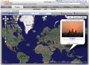
CyArk has projects from across the globe, including Angkor Wat, the world's largest reglious complex.
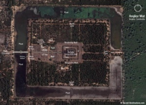
Using satellite images students can explore the landscape surrounding Angkor and investigate its role in the shaping of Angkor.
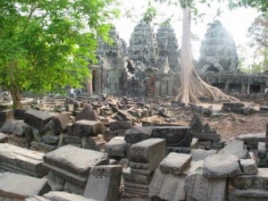
Banteay Kdei is on the verge of being swallowed by the surrounding jungle, an example of how the evironment can effect a site.
Related Articles:
Related Projects:
- 46