National Park Service Intermountain Region News Release
NPS announces the launch of virtual Fort Laramie

November 29, 2010
November 24, 2010: The National Park Service Intermountain Region formally announces the launch of a new way to virtually visit Fort Laramie National Historic Site in Wyoming.
This new web portal into the history of the early 19th century crossroads of the American wilderness was created in partnership between the Intermountain Region of the National Park Service (NPS) and CyArk.
John Wessels, Intermountain Region director for the Park Service, said an important aim of the virtual tour element is to allow park-goers to “visit” areas or features of a park that they cannot get to easily in person or that may be off-limits to the public because their resources are fragile.
“We are excited by this application of the power of technology for two great goals: Preserving our park resources better, and providing park visitors at home and around the world a richer understanding and experience of America’s historic and scenic heritage,” Wessels said.
With the help of the “Google Earth” computer application, visitors to the website “zoom” down from space to Fort Laramie, on the North Platte River. There, 3-D digital reconstructions show buildings and facilities at different periods in the fort’s history. Other features include a self-guided and narrated virtual tour, with 360-degree photo panoramas from numerous points on the fort grounds. The site also has extensive park archives, an interpretive history, historic and modern-day photos, Historic American Buildings Survey (HABS) drawings and other records.
“This takes documentation to a different level,” said Greg Kendrick, the Intermountain Region’s assistant regional director for External Affairs and Partnerships. “At Fort Laramie, we are going from two-dimensional, black-and-white photos and ink-on-Mylar drawings to a 3-D digital format. This is high definition and in color, and you can access it online. It’s kind of like going from The Andy Griffith Show of the 1960s to the movie Avatar.”
The wealth of digital content, including 3-D models of historic time periods of the fort, is being produced in a second partnership between CyArk and the University of Colorado Denver’s Center of Preservation Research.
“We are very excited about our partnership with the Park Service to better tell the story of an important site like Fort Laramie,” said Ben Kacyra, founder and director of CyArk . “This project has been a great experience, with the Intermountain Region helping us develop new ways to use digital 3-D to serve the public in an interesting, engaging way. The Fort Laramie project is truly a milestone for us. We look forward to applying this approach at many more sites to come.”
The Intermountain Region of NPS aims to develop the CyArk partnership into a long-term digital documentation program at parks in the region’s eight states: Arizona, Colorado, Montana, New Mexico, Oklahoma, Texas, Utah and Wyoming. Besides making parks more accessible and relevant to visitors and new audiences, the program goal is for parks and partner organizations to preserve precise digital images and records of nationally significant park resources.
Click here to read the full release.
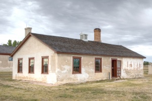
One of the photos of the Old Bakery at Fort Laramie
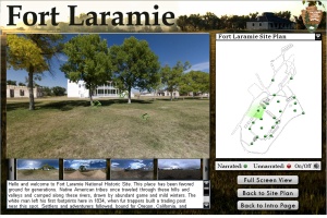
Preview image of the Fort Laramie Narrated <a href="/projects/FLA/misc/virtualtour/">Virtual Tour</a>
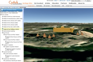
<a href=/fort-laramie-earth>Google Earth</a> interface for Fort Laramie, showing the model of the original Fort William