UKZN Technology Center Continues to Grow
UKZN and ACT receive 3rd consecutive year of digital preservation training
June 13, 2013
Late in the evening of Friday, May 24th, I boarded a plane (the first of three) to Durban, South Africa. Arriving sometime Sunday morning, I was greeted by colleague and friend, Michelle Dye. The rest of Sunday was pretty insignificant, mostly consisting of a hot shower and a long sleep (I never could sleep on planes so there was some catch-up rest needed).
Monday, however, began the third year of training for our Technology Center partner, University of KwaZulu-Natal. Over the past two years (2011, 2012) I have been working with UKZN and our co-collaborative partner, the African Conservation Trust, to teach CyArk's digital preservation methodologies to survey students working on the UKZN/ACT Heritage Mapping Unit project and Rock Art Mapping project. These two mapping projects were completed late last year and many of the students that were part of the initial projects and training have since successfully graduated and taken positions within the private survey sector. The intent of this year's week-long training session was to provide a focused refresher for the Geomatics lecturing staff in preparation for the next batch of students, and so I worked with three lecturers and a PhD student from UKZN and the GIS specialist from ACT.
We spent the week scanning, photographing, and post-processing data for the UKZN Howard College Campus' Centenary Building (the home of the Geomatics department). The aim was to build the skill and capacity of the Geomatics staff in basic digital preservation techniques. This is in advance of their beginning to integrate digital preservation and terrestrial laser scanning into student courses after the now-concluded Heritage Mapping and Rock Art Mapping projects.
CyArk's relationship with UKZN and ACT continues to thrive, and we look forward to future collaborative digital preservation projects being planned within the region. And I always look forward to my next South African adventure.
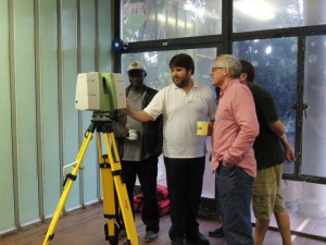
CyArk's Justin Barton shows UKZN Geomatics lecturers Mwitwa Chilufya, Carl Grossmann, and Angus Forbes some of the advanced features of the the Leica C10, such as custom window scans and target acquisition.

Geomatics lecturer Mwitwa Chilufya and Geomatics PhD Student Siboniso Dlamini are taught the basics of photography to capture well balanced HDR panoramas.
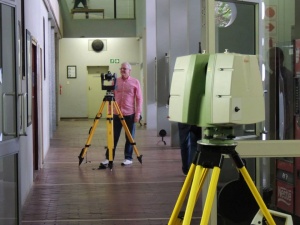
Angus Forbes, Senior Lecturer of the UKZN Geomatics Dept, operates a Gigapan to capture panoramic imagery to map on to 3D scan data as the scanner begins recording from the next setup location.